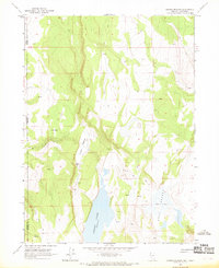
1966 Map of Crooks Meadow
USGS Topo · Published 1969About this map
Crooks Ranch sits at the heart of this high-desert landscape on the border of Nevada and California, representing the modest human footprint in a region defined by its water sources. The map illustrates a reliance on natural springs and seasonal basins, with Crooks Lake and Holy Lake serving as critical landmarks in an arid environment. The topography is etched with a network of trails and jeep trails, indicating how ranchers and travelers navigated Holy Valley and the surrounding slopes during the mid-1960s. These paths connect the ranch to numerous water points like Big Spring and various unnamed seeps, providing a clear picture of the land's utility for livestock and survival in the remote high country of Washoe and Modoc counties.
Find a feature on this map
13 named features on this map. Tap any name to fly to it.
Don’t see what you’re looking for? This feature index may not catch every label — zoom into the map to look around manually.
Map Details
Editions of this 1966 Crooks Meadow Map
2 editions found
Other maps of this area

1886 · Alturas
USGS Topo · 1:250,000

1889 · Long Valley
USGS Topo · 1:250,000

1892 · Alturas
USGS Topo · 1:250,000

1954 · Vya
USGS Topo · 1:250,000

1954 · Alturas
USGS Topo · 1:250,000

1958 · Alturas
USGS Topo · 1:250,000

1958 · Vya
USGS Topo · 1:250,000

1962 · Alturas
USGS Topo · 1:250,000

1962 · Vya
USGS Topo · 1:250,000

1962 · Cedarville
USGS Topo · 1:62,500