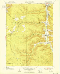
1950 Map of Crosby
USGS Topo · Published 1950About this map
Potato Creek carves a deep valley through the northern reaches of the McKean and Elk County line, serving as the primary corridor for settlement and transportation in this portion of Norwich and Sergeant townships. In the mid-twentieth century, the Pennsylvania railroad line tracks the creek's path, connecting small communities like Crosby, Colegrove, and Hamlin Sta. The landscape is defined by its deep hollows and high ridges, where industrial pipe lines traverse the plateaus, cutting across family-named landmarks such as Browns Mill Hol and Spangler Hol. Local heritage is anchored at the Clermont Cem and Norwich Cem, while the village of Clermont serves as a western highland hub. The transition from the steep valley of Red Mill Brook to the high southern hills near Jones township reveals an area deeply integrated with the extraction and transport infrastructure of the era.
Find a feature on this map
50 named features on this map. Tap any name to fly to it.
Don’t see what you’re looking for? This feature index may not catch every label — zoom into the map to look around manually.
Map Details
Editions of this 1950 Crosby Map
This is the sole edition of this map. No revisions or reprints were ever made.
Other maps of this area

1924 · Bradford
USGS Topo · 1:62,500

1926 · Bradford
USGS Topo · 1:62,500

1933 · Smethport
USGS Topo · 1:62,500

1935 · Mt. Jewett
USGS Topo · 1:48,000

1937 · Smethport
USGS Topo · 1:62,500

1940 · Mt. Jewett
USGS Topo · 1:62,500

1941 · Bradford
USGS Topo · 1:62,500

1944 · Bradford
USGS Topo · 1:62,500

1948 · Crosby
USGS Topo · 1:62,500

1948 · Wildwood Fire Tower
USGS Topo · 1:24,000
Featured Places
- Norwich Township, PA
- Crosby, Norwich Township
- Colegrove, Norwich Township
- Betula, Norwich Township
- Jones Township, PA