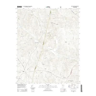
2014 Map of Cross Anchor
USGS Topo · Published 2014About this map
Cross Anchor and Cross Keys serve as the primary hubs in this corner of the Piedmont, where the boundary between Spartanburg and Union counties follows the winding path of Dutchman Creek. The landscape is defined by the Tyger River and its numerous tributaries, including Sugar Cr, Frenchman Cr, and Cowdens Cr. Historical crossings like Burnt Factory Bridge and Blackstocks Ford reflect the era's reliance on river-based transport and early manufacturing sites. In the northeast, the terrain rises toward Beddington Mtn near the community of Colerain. To the south, the map captures a portion of the Sumter National Forest, illustrating the transition from open agricultural lands to managed timber and conservation areas. Family-named landmarks and small settlements like Dutchman and Meadow Woods are interspersed with a high density of rural burial grounds, such as Grace Chapel Cem and Putnam Cem, which offer significant value for genealogical research in this historically agricultural region.
Find a feature on this map
77 named features on this map. Tap any name to fly to it.
Don’t see what you’re looking for? This feature index may not catch every label — zoom into the map to look around manually.
Map Details
Editions of this 2014 Cross Anchor Map
This is the sole edition of this map. No revisions or reprints were ever made.
Other maps of this area

1941 · Spartanburg
USGS Topo · 1:250,000

1947 · Spartanburg
USGS Topo · 1:62,500

1949 · Spartanburg
USGS Topo · 1:62,500

1953 · Spartanburg
USGS Topo · 1:250,000

1960 · Spartanburg
USGS Topo · 1:250,000

1963 · Spartanburg
USGS Topo · 1:250,000

1964 · Spartanburg
USGS Topo · 1:250,000

1969 · Cross Anchor
USGS Topo · 1:24,000

1969 · Ora
USGS Topo · 1:24,000
1969 · Enoree
USGS Topo · 1:24,000