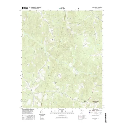
2017 Map of Cross Anchor
USGS Topo · Published 2017About this map
Dutchman and Cross Anchor serve as primary anchors for this rural landscape where the Tyger River winds through the Piedmont. The survey reveals a region defined by its watercourses and small family cemeteries, including Belmont Cem, Grace Chapel Cem, and New Hope Cem, which offer significant value for genealogists tracing South Carolina heritage. The terrain is marked by Beddington Mtn and an extensive network of creeks such as Frenchman Cr and Dutchman Creek. Infrastructure is notably tied to the river crossings at Vernon Bridge and the Burnt Factory Bridge, the latter name hinting at former local industries. Much of the southeastern portion of the map is dedicated to the Sumter National Forest, preserving the wooded character along the Spartanburg Co and Union Co line.
Find a feature on this map
66 named features on this map. Tap any name to fly to it.
Don’t see what you’re looking for? This feature index may not catch every label — zoom into the map to look around manually.
Map Details
Editions of this 2017 Cross Anchor Map
This is the sole edition of this map. No revisions or reprints were ever made.
Other maps of this area

1941 · Spartanburg
USGS Topo · 1:250,000

1947 · Spartanburg
USGS Topo · 1:62,500

1949 · Spartanburg
USGS Topo · 1:62,500

1953 · Spartanburg
USGS Topo · 1:250,000

1960 · Spartanburg
USGS Topo · 1:250,000

1963 · Spartanburg
USGS Topo · 1:250,000

1964 · Spartanburg
USGS Topo · 1:250,000

1969 · Cross Anchor
USGS Topo · 1:24,000

1969 · Ora
USGS Topo · 1:24,000
1969 · Enoree
USGS Topo · 1:24,000