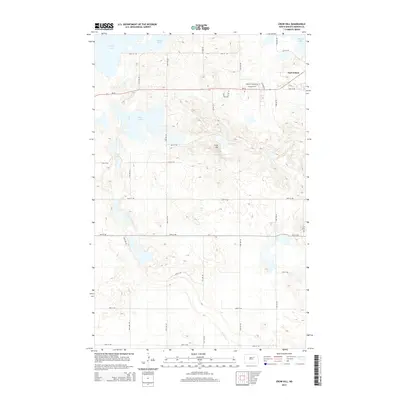
2014 Map of Crow Hill
USGS Topo · Published 2014About this map
Fort Totten and the shoreline of Devils Lake anchor this 2014 survey of the Benson County landscape. The terrain is characterized by the prominent elevation of Crow Hill and the scattered waters of the Twin Lakes area, reflecting the glacial topography of the North Dakota plains. The map reveals a transition from the established settlement patterns near the historic fort to the rural grid of the surrounding district, where roads like Baptist Church Rd and Walking Eagle Cir intersect with the primary corridor of Nd-57. This record of the Crow Hill District offers a detailed look at the modern road network, including the numeric grid from 32nd St NE to 40th St NE, showing how the land has been subdivided for contemporary use while maintaining its original hydrographic character.
Find a feature on this map
24 named features on this map. Tap any name to fly to it.
Don’t see what you’re looking for? This feature index may not catch every label — zoom into the map to look around manually.
Map Details
Editions of this 2014 Crow Hill Map
This is the sole edition of this map. No revisions or reprints were ever made.
Other maps of this area

1928 · Tokio
USGS Topo · 1:62,500

1931 · Oberon
USGS Topo · 1:62,500

1931 · Tokio
USGS Topo · 1:62,500

1931 · Devils Lake
USGS Topo · 1:62,500

1932 · Grahams Island
USGS Topo · 1:62,500

1950 · Oberon SW
USGS Topo · 1:24,000

1950 · Sheyenne
USGS Topo · 1:24,000
1950 · Tokio SW
USGS Topo · 1:24,000

1950 · Grahams Island
USGS Topo · 1:62,500

1950 · Devils Lake
USGS Topo · 1:62,500
Featured Places
- Crow Hill District, ND
- Fort Totten District, ND
- Fort Totten, Fort Totten District
- Benson County, ND
- United States