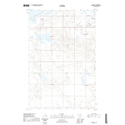
2020 Map of Crow Hill
USGS Topo · Published 2020About this map
Crow Hill rises as a central topographic landmark in this section of Benson County, surrounded by a landscape defined by prairie wetlands and the shifting southern reaches of Devils Lake. The area reflects a rural layout where Bureau of Indian Affairs routes like BIA Rd 7 and BIA Rd 24 intersect with local agricultural roads. For those tracing family history, the map identifies key community sites including the Saint Jeromes Catholic Cem in the northwest and the Christian Church Cem in the northeast. The presence of Baptist Church Rd and residential pockets like High Meadows and W Addition suggest a persistent, distributed community structure. The southern portion of the quadrangle is largely open terrain punctuated by unnamed seasonal basins and the Twin Lakes, illustrating the characteristic hydrography of the Spirit Lake Reservation region.
Find a feature on this map
32 named features on this map. Tap any name to fly to it.
Don’t see what you’re looking for? This feature index may not catch every label — zoom into the map to look around manually.
Map Details
Editions of this 2020 Crow Hill Map
This is the sole edition of this map. No revisions or reprints were ever made.
Other maps of this area

1928 · Tokio
USGS Topo · 1:62,500

1931 · Oberon
USGS Topo · 1:62,500

1931 · Tokio
USGS Topo · 1:62,500

1931 · Devils Lake
USGS Topo · 1:62,500

1932 · Grahams Island
USGS Topo · 1:62,500

1950 · Oberon SW
USGS Topo · 1:24,000

1950 · Sheyenne
USGS Topo · 1:24,000
1950 · Tokio SW
USGS Topo · 1:24,000

1950 · Grahams Island
USGS Topo · 1:62,500

1950 · Devils Lake
USGS Topo · 1:62,500
Featured Places
- Crow Hill District, ND
- Fort Totten District, ND
- Fort Totten, Fort Totten District
- Benson County, ND
- United States