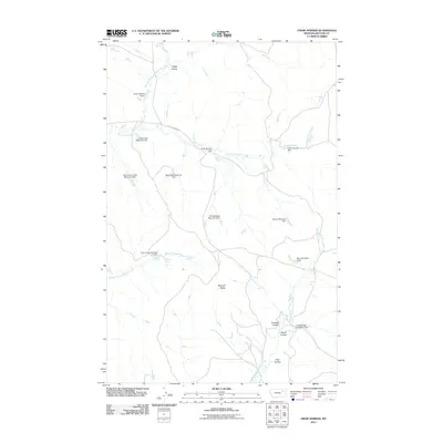
2011 Map of Crow Springs
USGS Topo · Published 2011About this map
Crow Springs serves as a focal point in this section of McCone County, where a network of coulees and earthen dams manages the intermittent flow of water across the High Plains. The landscape is dominated by the drainages of the South Fork Rock Creek and North Fork McGuire Creek, which are punctuated by numerous small reservoirs such as Bobcat Reservoir Dam and Horse Trough Dam. These features, often bearing the names of local ranching families like the Pawlowski and Towe families, suggest a history of private land management and water conservation in an arid environment. Rising above the drainage networks is Bonhoff Butte, providing a significant topographical landmark in an area otherwise defined by sweeping coulees like Antelope Coulee and Roald Coulee. The presence of E Rock Creek Rd indicates the primary transit corridor linking these remote ranching sites and water sources.
Find a feature on this map
25 named features on this map. Tap any name to fly to it.
Don’t see what you’re looking for? This feature index may not catch every label — zoom into the map to look around manually.
Map Details
Editions of this 2011 Crow Springs Map
This is the sole edition of this map. No revisions or reprints were ever made.
Other maps of this area

1954 · Jordan
USGS Topo · 1:250,000

1954 · Glendive
USGS Topo · 1:250,000

1956 · Jordan
USGS Topo · 1:250,000

1957 · Glendive
USGS Topo · 1:250,000

1958 · Jordan
USGS Topo · 1:250,000

1958 · Glendive
USGS Topo · 1:250,000

1964 · Jordan
USGS Topo · 1:250,000

1973 · Crow Springs
USGS Topo · 1:24,000
1973 · Willis Buttes
USGS Topo · 1:24,000
1973 · Sand Arroyo
USGS Topo · 1:24,000