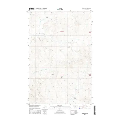
2017 Map of Crow Springs
USGS Topo · Published 2017About this map
Crow Springs serves as a central landmark for this high plains landscape in eastern Montana. The terrain is defined by a dense network of coulees and springs, illustrating the critical role of water sources in this semi-arid region. Named features such as Heagy Coulee, Anderson Coulee, and Roald Coulee show how the local geography was categorized by early ranching or homesteading interests. Notable water points like Bonin Springs, Norris Springs, and Solhaug Spring are scattered across the quadrangle, likely serving as historic watering holes for livestock. The landscape is punctuated by Bonhoff Butte and bisected by E Rock Creek Rd, providing a clear view of the drainage patterns for the Middle Fork S Fork Rock Cr and the complex McGuire Creek system including N Fork McGuire Cr and S Fork McGuire Cr.
Find a feature on this map
20 named features on this map. Tap any name to fly to it.
Don’t see what you’re looking for? This feature index may not catch every label — zoom into the map to look around manually.
Map Details
Editions of this 2017 Crow Springs Map
This is the sole edition of this map. No revisions or reprints were ever made.
Other maps of this area

1954 · Jordan
USGS Topo · 1:250,000

1954 · Glendive
USGS Topo · 1:250,000

1956 · Jordan
USGS Topo · 1:250,000

1957 · Glendive
USGS Topo · 1:250,000

1958 · Jordan
USGS Topo · 1:250,000

1958 · Glendive
USGS Topo · 1:250,000

1964 · Jordan
USGS Topo · 1:250,000

1973 · Crow Springs
USGS Topo · 1:24,000
1973 · Willis Buttes
USGS Topo · 1:24,000
1973 · Sand Arroyo
USGS Topo · 1:24,000