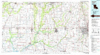
1985 Map of Crowley
USGS Topo · Published 1988About this map
The rice-farming prairies of Southwest Louisiana are documented here in the mid-1980s, centered on the hub of Crowley and the surrounding Acadiana region. The landscape is defined by an intricate network of waterways, including Bayou Plaquemine Brule and the Mermentau River, which feed into the expansive Lake Arthur to the south. This era shows a region balanced between its agricultural roots and industrial transport, with both the Southern Pacific RR and Missouri Pacific RR traversing the territory to connect towns like Jennings and Welsh.
Find a feature on this map
124 named features on this map. Tap any name to fly to it.
Don’t see what you’re looking for? This feature index may not catch every label — zoom into the map to look around manually.
Map Details
Editions of this 1985 Crowley Map
2 editions found

Other maps of this area

1932 · Lake Charles NE
USGS Topo · 1:31,680

1932 · Abbeville NE
USGS Topo · 1:31,680

1932 · Abbeville NW
USGS Topo · 1:31,680

1932 · Lake Charles SE
USGS Topo · 1:31,680

1934 · Duson
USGS Topo · 1:31,680
1934 · Lake Misere
USGS Topo · 1:24,000

1934 · Boudreaux Lake
USGS Topo · 1:24,000

1934 · Latania Lake
USGS Topo · 1:24,000

1935 · Branch
USGS Topo · 1:31,680

1935 · Lake Misere
USGS Topo · 1:31,680