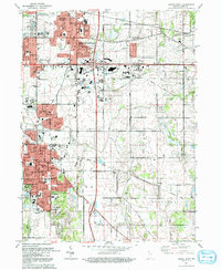
1992 Map of Crown Point
USGS Topo · Published 1992About this map
Merrillville and Crown Point serve as the primary hubs in this late twentieth-century landscape, characterized by significant suburban expansion and a dense network of civic institutions. The map illustrates a transition from the structured street grids of established settlements to the modern development patterns of Independence Hill and Green Acres. A high concentration of religious and medical landmarks, such as St Sava Ch, Methodist Hospital, and St Anthony Hospital, reflects the area's growing role as a regional center.
Find a feature on this map
74 named features on this map. Tap any name to fly to it.
Don’t see what you’re looking for? This feature index may not catch every label — zoom into the map to look around manually.
Map Details
Editions of this 1992 Crown Point Map
This is the sole edition of this map. No revisions or reprints were ever made.
Other maps of this area

1900 · Toleston
USGS Topo · 1:62,500

1934 · Porter
USGS Topo · 1:48,000

1940 · Porter
USGS Topo · 1:62,500

1953 · Leroy
USGS Topo · 1:24,000

1953 · St. John
USGS Topo · 1:24,000

1953 · Palmer
USGS Topo · 1:24,000

1953 · Gary
USGS Topo · 1:24,000

1953 · Crown Point
USGS Topo · 1:24,000

1953 · Hebron
USGS Topo · 1:24,000

1953 · Garyton
USGS Topo · 1:24,000