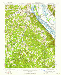
1949 Map of Crystal City
USGS Topo · Published 1959About this map
Crystal City and Festus stand as the primary industrial and residential hubs along the western bank of the Mississippi River, where the Missouri Pacific and St Louis-San Francisco railroads converge. This mid-century survey reveals a landscape defined by its deep relationship with the river, from the low-lying Calico Island and Harlow Island to the dramatic elevation of the Harrisonville Bluffs across the Illinois border.
Find a feature on this map
79 named features on this map. Tap any name to fly to it.
Don’t see what you’re looking for? This feature index may not catch every label — zoom into the map to look around manually.
Map Details
Editions of this 1949 Crystal City Map
2 editions found

Other maps of this area

1901 · De Soto
USGS Topo · 1:125,000

1904 · Farmington
USGS Topo · 1:62,500

1905 · Bonneterre
USGS Topo · 1:62,500

1906 · Farmington
USGS Topo · 1:62,500

1907 · Weingarten
USGS Topo · 1:62,500

1909 · Weingarten
USGS Topo · 1:62,500

1910 · Waterloo
USGS Topo · 1:62,500

1912 · Kimmswick
USGS Topo · 1:62,500

1913 · Waterloo
USGS Topo · 1:62,500

1915 · Renault
USGS Topo · 1:62,500