
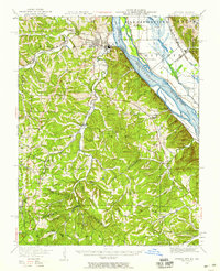
1949 Map of Crystal City
USGS Topo · Published 1959About this map
Festus and Crystal City serve as the industrial anchors along the Mississippi River in this mid-century portrait of eastern Missouri. The landscape is defined by the sharp transition from the river bottomlands, including Harlow Island and Rush Island, to the complex topography of the Joachim and Plattin districts. The map documents a dense network of early rural infrastructure, specifically noting an abundance of local schools such as Telegraph School and High Ridge School that served these valley communities. Evidence of the region's mineral history and rail development is clear, with the Missouri Pacific RR and St Louis and San Francisco RR following the natural contours of the creeks. Near Valle Mines, the terrain becomes particularly intricate, illustrating the rugged hills that historically isolated these mining and farming settlements from the riverfront hubs.
Find a feature on this map
80 named features on this map. Tap any name to fly to it.
Don’t see what you’re looking for? This feature index may not catch every label — zoom into the map to look around manually.
Map Details
Editions of this 1949 Crystal City Map
2 editions found
Other maps of this area

1901 · De Soto
USGS Topo · 1:125,000

1904 · Farmington
USGS Topo · 1:62,500

1905 · Bonneterre
USGS Topo · 1:62,500

1906 · Farmington
USGS Topo · 1:62,500

1907 · Weingarten
USGS Topo · 1:62,500

1909 · Weingarten
USGS Topo · 1:62,500

1910 · Waterloo
USGS Topo · 1:62,500

1912 · Kimmswick
USGS Topo · 1:62,500

1913 · Waterloo
USGS Topo · 1:62,500

1915 · Renault
USGS Topo · 1:62,500