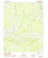
1984 Map of Crystal Crag
USGS Topo · Published 1984About this map
Devils Postpile National Monument serves as a central landmark in this 1984 survey, situated where the Middle Fork San Joaquin River passes through a corridor between the Minarets Wilderness and Inyo National Forest. The map documents a high-altitude landscape defined by heavy-use recreational corridors, specifically the intersection of the Pacific Crest National Scenic Trail and the John Muir Trail. In the northeastern corner, a dense cluster of alpine water bodies including Lake Mary, Lake Mamie, and Horseshoe Lake indicates a transition from the backcountry to established campgrounds and seasonal access points like Mammoth Pass. Further south, the terrain drops into Fish Creek Valley, where remote sites such as Iva Bell Hot Springs and the geologic formation of Pumice Butte suggest the geothermal and volcanic history that shaped this section of the Sierra Nevada.
Find a feature on this map
53 named features on this map. Tap any name to fly to it.
Don’t see what you’re looking for? This feature index may not catch every label — zoom into the map to look around manually.
Map Details
Editions of this 1984 Crystal Crag Map
This is the sole edition of this map. No revisions or reprints were ever made.
Other maps of this area

1901 · Mt. Lyell
USGS Topo · 1:125,000

1904 · Kaiser
USGS Topo · 1:125,000

1912 · Mt. Goddard
USGS Topo · 1:125,000

1914 · Mt. Morrison
USGS Topo · 1:125,000

1947 · Mariposa
USGS Topo · 1:250,000

1948 · Mariposa
USGS Topo · 1:250,000

1953 · Mt. Morrison
USGS Topo · 1:62,500

1953 · Mt Abbot
USGS Topo · 1:62,500

1953 · Devils Postpile
USGS Topo · 1:62,500

1953 · Kaiser Peak
USGS Topo · 1:62,500