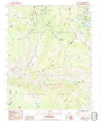
1992 Map of Crystal Crag
USGS Topo · Published 1995About this map
Devils Postpile stands as the central landmark of this high-elevation mountain terrain where the boundaries of the Ansel Adams Wilderness and John Muir Wilderness converge. The landscape is defined by the canyon of the Middle Fork San Joaquin River, featuring Rainbow Falls and Lower Falls, alongside the glacial basins of the Mammoth Lakes area. Transportation across the crest is limited to storied footpaths, including the John Muir Trail and the Pacific Crest National Scenic Trail, which navigate through Mammoth Pass. These routes connect remote meadows and springs like Reds Meadow to the high-alpine lakes such as Lake Mary, Lake George, and Crystal Lake. Geologic features like the Dragons Back, Pumice Butte, and the namesake Crystal Crag illustrate the volcanic and glacial forces that shaped this portion of the Sierra Nevada.
Find a feature on this map
53 named features on this map. Tap any name to fly to it.
Don’t see what you’re looking for? This feature index may not catch every label — zoom into the map to look around manually.
Map Details
Editions of this 1992 Crystal Crag Map
This is the sole edition of this map. No revisions or reprints were ever made.
Other maps of this area

1901 · Mt. Lyell
USGS Topo · 1:125,000

1904 · Kaiser
USGS Topo · 1:125,000

1912 · Mt. Goddard
USGS Topo · 1:125,000

1914 · Mt. Morrison
USGS Topo · 1:125,000

1947 · Mariposa
USGS Topo · 1:250,000

1948 · Mariposa
USGS Topo · 1:250,000

1953 · Mt. Morrison
USGS Topo · 1:62,500

1953 · Mt Abbot
USGS Topo · 1:62,500

1953 · Devils Postpile
USGS Topo · 1:62,500

1953 · Kaiser Peak
USGS Topo · 1:62,500