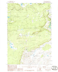
1986 Map of Crystal Falls
USGS Topo · Published 1986About this map
Solfatara Plateau and the Central Plateau dominate this 1986 survey of the heart of Yellowstone National Park. This landscape is defined by its thermal features and water systems, where Violet Springs feeds into Violet Creek before reaching the larger Alum Creek drainage. The map captures a high-altitude wilderness shaped by volcanic history and glacial activity, visible in the cluster of lakes including Wolf Lake, Grebe Lake, and Cascade Lake.
Find a feature on this map
23 named features on this map. Tap any name to fly to it.
Don’t see what you’re looking for? This feature index may not catch every label — zoom into the map to look around manually.
Map Details
Editions of this 1986 Crystal Falls Map
This is the sole edition of this map. No revisions or reprints were ever made.
Other maps of this area

1885 · Gallatin
USGS Topo · 1:125,000

1885 · Gallatin
USGS Topo · 1:125,000

1886 · Canyon
USGS Topo · 1:125,000

1895 · Canyon
USGS Topo · 1:125,000

1896 · Canyon
USGS Topo · 1:125,000

1901 · Canyon
USGS Topo · 1:125,000

1901 · Gallatin
USGS Topo · 1:125,000

1907 · Canyon
USGS Topo · 1:125,000

1908 · Gallatin
USGS Topo · 1:125,000

1911 · Gallatin
USGS Topo · 1:125,000