
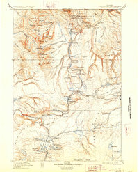
1911 Map of Gallatin
USGS Topo · Published 1911About this map
Fort Yellowstone stands as a primary outpost on this early 20th-century topographic record, marking the military administration of the region before the creation of the National Park Service. The map details a complex landscape of thermal activity and early tourism infrastructure, centered around the Mammoth Hot Springs and the Norris Geyser Basin. Travel routes of the era are clearly delineated, including the Snow Pass Trail and the Cooke Road, alongside early hotel developments such as the Fountain Hotel and Mammoth Hotel. Beyond the established geothermal hubs, the survey tracks the high-altitude terrain of the Gallatin Range and the Madison Plateau, documenting the sources of the Gallatin River and Madison River. Notable landmarks like Liberty Cap and the Artist Paintpots are recorded alongside vital river crossings like Chittenden Bridge, illustrating how early visitors navigated this hydrothermal wilderness.
Find a feature on this map
147 named features on this map. Tap any name to fly to it.
Don’t see what you’re looking for? This feature index may not catch every label — zoom into the map to look around manually.
Map Details
Editions of this 1911 Gallatin Map
2 editions found
Other maps of this area

1885 · Lake
USGS Topo · 1:125,000

1885 · Gallatin
USGS Topo · 1:125,000

1885 · Gallatin
USGS Topo · 1:125,000

1886 · Shoshone
USGS Topo · 1:125,000

1886 · Canyon
USGS Topo · 1:125,000

1888 · Three Forks
USGS Topo · 1:250,000

1888 · Shoshone
USGS Topo · 1:125,000

1891 · Livingston
USGS Topo · 1:250,000

1893 · Livingston
USGS Topo · 1:250,000

1894 · Three Forks
USGS Topo · 1:250,000