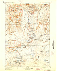
1911 Map of Gallatin
USGS Topo · Published 1928About this map
Mammoth Hot Springs and the northern reaches of the Gallatin Range define this landscape during a period of significant early park development. The map details the administrative and tourism infrastructure of the era, from the Park Headquarters and Mammoth Hotel to the Mammoth Permanent Camp. A notable shift in travel patterns is evident in the labeling of both the Norris Basin Hotel and Fountain Hotel as abandoned, reflecting the rapid changes in park hospitality at the turn of the century.
Find a feature on this map
147 named features on this map. Tap any name to fly to it.
Don’t see what you’re looking for? This feature index may not catch every label — zoom into the map to look around manually.
Map Details
Editions of this 1911 Gallatin Map
2 editions found

Other maps of this area

1885 · Lake
USGS Topo · 1:125,000

1885 · Gallatin
USGS Topo · 1:125,000

1885 · Gallatin
USGS Topo · 1:125,000

1886 · Shoshone
USGS Topo · 1:125,000

1886 · Canyon
USGS Topo · 1:125,000

1888 · Three Forks
USGS Topo · 1:250,000

1888 · Shoshone
USGS Topo · 1:125,000

1891 · Livingston
USGS Topo · 1:250,000

1893 · Livingston
USGS Topo · 1:250,000

1894 · Three Forks
USGS Topo · 1:250,000