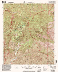
1995 Map of Crystal Lake
USGS Topo · Published 1999About this map
The Crystal Lake Recreation Area serves as the central hub of this 1995 survey, which details a high-elevation landscape within the Angeles National Forest. Significant peaks dominate the horizon, from the towering Mount Baden-Powell and its nearby BSA Monument to the heights of Mount Islip and Mount Hawkins. The map documents a critical intersection of high-country infrastructure, including the winding Angeles Crest Highway and the Pacific Crest Trail, which traverses the ridge lines between Islip Saddle and Dawson Saddle. Historically, this area represents a preserved mountain corridor defined by its transition from the San Gabriel Wilderness to the Sheep Mountain Wilderness. Localized sites like Crystal Lake Station, Pine Flat, and the Valley of the Moon Plantation provide evidence of forest management and early recreational development along the headwaters of the San Gabriel River.
Find a feature on this map
57 named features on this map. Tap any name to fly to it.
Don’t see what you’re looking for? This feature index may not catch every label — zoom into the map to look around manually.
Map Details
Editions of this 1995 Crystal Lake Map
This is the sole edition of this map. No revisions or reprints were ever made.
Other maps of this area

1894 · Pomona
USGS Topo · 1:62,500

1897 · Pomona
USGS Topo · 1:62,500

1897 · Cucamonga
USGS Topo · 1:62,500

1898 · Pomona
USGS Topo · 1:62,500

1900 · Cucamonga
USGS Topo · 1:62,500

1901 · Southern California Sheet No. 1
USGS Topo · 1:250,000

1903 · Rock Creek
USGS Topo · 1:62,500

1903 · Cucamonga
USGS Topo · 1:62,500

1903 · San Antonio
USGS Topo · 1:62,500

1904 · Pomona
USGS Topo · 1:62,500