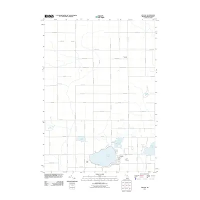
2011 Map of Crystal
USGS Topo · Published 2011About this map
Crystal serves as the central hub of this eastern Montcalm County landscape, where the town's grid meets the eastern banks of Crystal Lake. The area's recreational character is evident in the lakeside South Shore Campground, the Crystal Golf Course, and the high-octane Crystal Motor Speedway just east of the village center. This 2011 survey documents a mix of agricultural sections and natural water features, including Fish Creek winding through the northern reaches and a series of smaller bodies such as Loon Lake, Mud Lake, and Lake Steven. Genealogists will find the Ferris Center Cemetery prominently marked in the northeast, positioned at a rural crossroads along E Newcomb Rd. The road network, including arterial routes like Vickeryville Rd and N Crystal Rd, defines a landscape shaped by both traditional farming and the enduring draw of the region's lakes.
Find a feature on this map
61 named features on this map. Tap any name to fly to it.
Don’t see what you’re looking for? This feature index may not catch every label — zoom into the map to look around manually.
Map Details
Editions of this 2011 Crystal Map
This is the sole edition of this map. No revisions or reprints were ever made.
Other maps of this area

1954 · Midland
USGS Topo · 1:250,000

1958 · Midland
USGS Topo · 1:250,000

1959 · Midland
USGS Topo · 1:250,000

1964 · Edmore
USGS Topo · 1:24,000

1964 · Stanton
USGS Topo · 1:24,000

1965 · Vestaburg
USGS Topo · 1:24,000

1965 · Sumner
USGS Topo · 1:24,000

1965 · Crystal
USGS Topo · 1:24,000
1965 · Riverdale
USGS Topo · 1:24,000

1966 · Midland
USGS Topo · 1:250,000