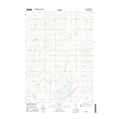
2017 Map of Crystal
USGS Topo · Published 2017About this map
Crystal serves as the focal point of this Montcalm County landscape, situated on the eastern shore of the expansive Crystal Lake. The settlement pattern reflects a transition from the dense lakeside development near Belding St to the organized agricultural grid defined by E Stanton Rd and Kimball Rd NE. This 2017 survey reveals a region defined by its hydrology, where numerous smaller bodies of water like Loon Lake, Mud Lake, and Lake Steven are interspersed among the farmland. To the north, the Ferris Center Cem stands as a significant genealogical landmark along Newcomb Rd. The drainage network, including Fish Cr and Carpenter Cr, illustrates the natural flow of the terrain towards the larger lake basin, while the township boundaries of t11n r5w and t10n r5w provide the formal structure for this rural community.
Find a feature on this map
70 named features on this map. Tap any name to fly to it.
Don’t see what you’re looking for? This feature index may not catch every label — zoom into the map to look around manually.
Map Details
Editions of this 2017 Crystal Map
This is the sole edition of this map. No revisions or reprints were ever made.
Other maps of this area

1954 · Midland
USGS Topo · 1:250,000

1958 · Midland
USGS Topo · 1:250,000

1959 · Midland
USGS Topo · 1:250,000

1964 · Edmore
USGS Topo · 1:24,000

1964 · Stanton
USGS Topo · 1:24,000

1965 · Vestaburg
USGS Topo · 1:24,000

1965 · Sumner
USGS Topo · 1:24,000

1965 · Crystal
USGS Topo · 1:24,000
1965 · Riverdale
USGS Topo · 1:24,000

1966 · Midland
USGS Topo · 1:250,000