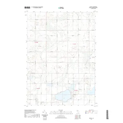
2019 Map of Crystal
USGS Topo · Published 2019About this map
Crystal serves as the primary hub of this lakeside community, centered on the southern shore of Crystal Lake. The landscape is defined by its glacial hydrology, with smaller water bodies like Loon Lake, Mud Lake, and Duck Lake scattered across the township lines of t10n r5w and t11n r5w. These lakes are joined by drainage features such as Fish Cr, which meanders through the marshy lowlands typical of this part of Montcalm County. For those tracing family histories, the Ferris Center Cem stands near the intersection of Newcomb Rd and Co Rd 545, providing a key genealogical anchor in the northern portion of the quadrangle. The 2019 survey shows a developed grid of rural roads, including Kendaville Rd and Sidney Rd, which connect the scattered agricultural tracts and lakeside residences.
Find a feature on this map
42 named features on this map. Tap any name to fly to it.
Don’t see what you’re looking for? This feature index may not catch every label — zoom into the map to look around manually.
Map Details
Editions of this 2019 Crystal Map
This is the sole edition of this map. No revisions or reprints were ever made.
Other maps of this area

1954 · Midland
USGS Topo · 1:250,000

1958 · Midland
USGS Topo · 1:250,000

1959 · Midland
USGS Topo · 1:250,000

1964 · Edmore
USGS Topo · 1:24,000

1964 · Stanton
USGS Topo · 1:24,000

1965 · Vestaburg
USGS Topo · 1:24,000

1965 · Sumner
USGS Topo · 1:24,000

1965 · Crystal
USGS Topo · 1:24,000
1965 · Riverdale
USGS Topo · 1:24,000

1966 · Midland
USGS Topo · 1:250,000