1966 Map of Crystal
USGS Topo · Published 1992About this map
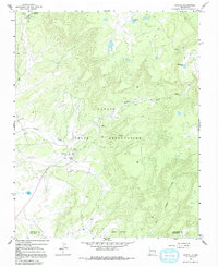
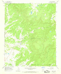
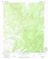
Crystal serves as the central hub within the Navajo Indian Reservation on this 1960s-era topographic survey, straddling the county line between San Juan and McKinley Counties. The settlement is situated near the convergence of several drainages, most notably Crystal Creek, and features essential infrastructure such as Sewage Disposal Ponds and a Water Tank. The high-altitude landscape is dotted with several significant water bodies, including Todacheene Lake and Berland Lake to the north, and Sage Lake to the southwest. For those researching local burial sites or family history, the map identifies a specific Cem south of the main settlement and a lone Grave to the northwest. The terrain is defined by complex drainage systems like Bowl Canyon Creek and Whiskey Cr, illustrating the vital role of seasonal and permanent water sources like Vicenti Spring in this high-desert environment.
Find a feature on this map
18 named features on this map. Tap any name to fly to it.
Don’t see what you’re looking for? This feature index may not catch every label — zoom into the map to look around manually.
Map Details
Editions of this 1966 Crystal Map
3 editions found
Other maps of this area

1886 · Wingate
USGS Topo · 1:250,000

1886 · Fort Defiance
USGS Topo · 1:250,000

1889 · Chaco
USGS Topo · 1:250,000

1892 · Fort Defiance
USGS Topo · 1:250,000

1892 · Wingate
USGS Topo · 1:250,000

1892 · Chaco
USGS Topo · 1:250,000

1892 · Canyon De Chelly
USGS Topo · 1:250,000

1954 · Shiprock
USGS Topo · 1:250,000

1954 · Gallup
USGS Topo · 1:250,000
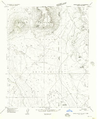
1955 · Sonsala Butte 4 SE
USGS Topo · 1:24,000
Featured Places
- Shiprock Agency
- Fort Defiance Agency
- Crystal, Fort Defiance Agency
- Áshįįshzhiin, Fort Defiance Agency
- San Juan County, NM