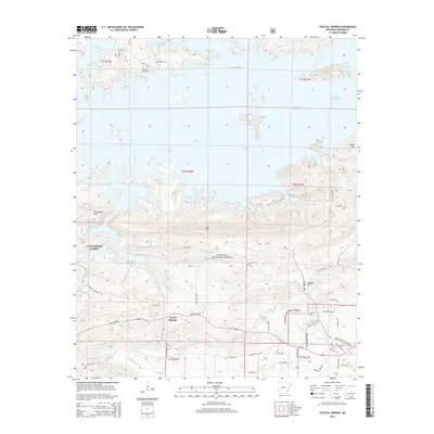
2014 Map of Crystal Springs
USGS Topo · Published 2014About this map
Lake Ouachita dominates the northern half of this landscape, its complex shoreline creating numerous coves and inlets within the Ouachita National Forest. The settlement of Crystal Springs serves as a central hub south of the water, connected by Albert Pike Rd and S Crystal Springs Rd. Genealogists will find significant value in the mapped locations of Buckville Cemeteries and Brooks Cem near the lake's northern edge, as well as Lowe Cem further south. The terrain is defined by prominent peaks including Hickorynut Mtn and Bear Mtn, while the small community of Bear sits at the junction of Owl Creek Rd and Old Bear Rd. The transition from the water's edge at Crystal Springs Landing to the dense network of forest roads like Rouse Creek Pl and Brady Mountain Cutoff illustrates the intersection of recreation and timber management in this part of Arkansas.
Find a feature on this map
55 named features on this map. Tap any name to fly to it.
Don’t see what you’re looking for? This feature index may not catch every label — zoom into the map to look around manually.
Map Details
Editions of this 2014 Crystal Springs Map
This is the sole edition of this map. No revisions or reprints were ever made.
Other maps of this area

1890 · Hot Springs
USGS Topo · 1:125,000

1894 · Hot Springs
USGS Topo · 1:125,000

1955 · Little Rock
USGS Topo · 1:250,000

1956 · Little Rock
USGS Topo · 1:250,000

1960 · Little Rock
USGS Topo · 1:250,000

1962 · Crystal Springs
USGS Topo · 1:24,000

1962 · Avant
USGS Topo · 1:24,000

1962 · Fannie
USGS Topo · 1:24,000

1962 · Mc Graw Mountain
USGS Topo · 1:24,000

1964 · Little Rock
USGS Topo · 1:250,000