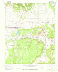
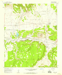
1957 Map of Cubero
USGS Topo · Published 1973About this map
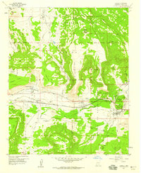
The Atchison Topeka and Santa Fe railroad corridor defines the central valley of this New Mexico landscape, following the course of the Rio San Jose. This region is a complex intersection of historic land grants and tribal lands, including the Laguna Indian Reservation, Acoma Pueblo Grant, and Cubero Grant. Small settlements and missions dot the valley floor, such as St Anne Mission and the Acomita Sch near West Village.
Find a feature on this map
43 named features on this map. Tap any name to fly to it.
Don’t see what you’re looking for? This feature index may not catch every label — zoom into the map to look around manually.
Map Details
Editions of this 1957 Cubero Map
2 editions found
Other maps of this area

1883 · Mt. Taylor
USGS Topo · 1:250,000

1886 · Mt. Taylor
USGS Topo · 1:250,000

1892 · Mt. Taylor
USGS Topo · 1:250,000

1899 · Mt. Taylor
USGS Topo · 1:250,000

1917 · Cerro Verde
USGS Topo · 1:125,000

1917 · Broom Mountain
USGS Topo · 1:125,000

1954 · Socorro
USGS Topo · 1:250,000
1957 · Lobo Springs
USGS Topo · 1:24,000
1957 · Mount Taylor
USGS Topo · 1:24,000
1957 · Laguna
USGS Topo · 1:24,000