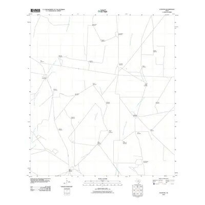
2010 Map of Cuevitas
USGS Topo · Published 2010About this map
Cuevitas and San Roman sit within a landscape defined by an extensive network of ranching infrastructure and intermittent watercourses in southern Texas. The geography is dominated by a high density of named windmills, which serve as critical landmarks for local history and genealogy in this arid environment. These features, such as the Ebanito Windmills, Reforma Windmill, and Casa Verde Windmill, indicate long-standing land divisions and the vital role of water management in the region's cattle-raising heritage. The drainage patterns of Remadura de Charco Largo Creek, Los Olmos Creek, and Remadura de Sandia Creek dictate the local topography, while FM 649 and Felipes LN provide the primary transit corridors through these sparsely populated ranchlands. Each named site, from Pitalla Windmill to the San Eduardo Windmills, provides a specific point of reference for tracing family landholdings and the development of local agricultural operations.
Find a feature on this map
31 named features on this map. Tap any name to fly to it.
Don’t see what you’re looking for? This feature index may not catch every label — zoom into the map to look around manually.
Map Details
Editions of this 2010 Cuevitas Map
This is the sole edition of this map. No revisions or reprints were ever made.
Other maps of this area

1938 · El Sauz
USGS Topo · 1:62,500

1938 · Agua Nueva
USGS Topo · 1:62,500

1938 · Sal Colorada
USGS Topo · 1:62,500

1938 · Cuevitas
USGS Topo · 1:62,500

1949 · Mc Allen
USGS Topo · 1:250,000

1954 · McAllen
USGS Topo · 1:250,000

1957 · Mc Allen
USGS Topo · 1:250,000

1962 · McAllen
USGS Topo · 1:250,000

1972 · Cuevitas
USGS Topo · 1:24,000
1972 · Guerra
USGS Topo · 1:24,000