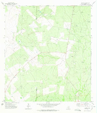
1972 Map of Guerra
USGS Topo · Published 1975About this map
Guerra serves as the focal point of this South Texas landscape, situated near the boundary line of Zapata Co Jim Hogg Co. The terrain is defined by a sparse but organized ranching and industrial infrastructure, where water sources are marked by specifically named landmarks like Mesquite Windmill and Old Medanito Windmill. These stations, essential for livestock in the semi-arid brush country, dot the land alongside evidence of the region's energy economy.
Find a feature on this map
17 named features on this map. Tap any name to fly to it.
Don’t see what you’re looking for? This feature index may not catch every label — zoom into the map to look around manually.
Map Details
Editions of this 1972 Guerra Map
2 editions found
Other maps of this area

1938 · Cuevitas
USGS Topo · 1:62,500

1939 · Randado
USGS Topo · 1:62,500

1940 · Randado
USGS Topo · 1:62,500

1940 · Mogotes Hill
USGS Topo · 1:62,500

1949 · Mc Allen
USGS Topo · 1:250,000

1954 · McAllen
USGS Topo · 1:250,000

1956 · Mogotes Hill
USGS Topo · 1:62,500

1956 · Arroyo Clareno
USGS Topo · 1:62,500

1956 · Laredo
USGS Topo · 1:250,000

1957 · Mc Allen
USGS Topo · 1:250,000