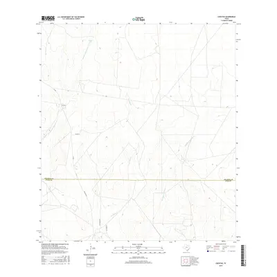
2016 Map of Cuevitas
USGS Topo · Published 2016About this map
The borderlands of Starr and Jim Hogg counties unfold across this 2016 survey, where the sparse ranching landscape of South Texas is defined by seasonal watercourses and long-established property lines. The small settlement of Cuevitas serves as a primary point of reference, situated near the western edge of the quadrangle. The terrain is etched by several notable arroyos, including Los Olmos Cr, Remadura de Charco Largo Cr, and Remadura de Sandia Cr, which carve through the brush country. These drainages, along with man-made water sources like Carreta Tank, illustrate the critical importance of water management in this arid environment. Transportation through the area is facilitated by Ranch Rd 649, which connects scattered homesteads and legacy holdings like the San Roman Rch and residents along Villarreal Rd, reflecting the enduring cattle-ranching heritage of the region.
Find a feature on this map
12 named features on this map. Tap any name to fly to it.
Don’t see what you’re looking for? This feature index may not catch every label — zoom into the map to look around manually.
Map Details
Editions of this 2016 Cuevitas Map
This is the sole edition of this map. No revisions or reprints were ever made.
Other maps of this area

1938 · El Sauz
USGS Topo · 1:62,500

1938 · Agua Nueva
USGS Topo · 1:62,500

1938 · Sal Colorada
USGS Topo · 1:62,500

1938 · Cuevitas
USGS Topo · 1:62,500

1949 · Mc Allen
USGS Topo · 1:250,000

1954 · McAllen
USGS Topo · 1:250,000

1957 · Mc Allen
USGS Topo · 1:250,000

1962 · McAllen
USGS Topo · 1:250,000

1972 · Cuevitas
USGS Topo · 1:24,000
1972 · Guerra
USGS Topo · 1:24,000