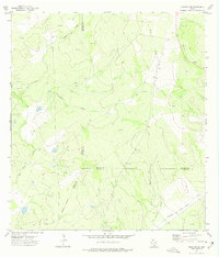
1972 Map of Cuevitas SW
USGS Topo · Published 1975About this map
El Javali Oil Field and the Marks Oil Field dominate this 1970s landscape where the borders of Jim Hogg, Starr, and Zapata counties converge. The terrain is defined by an extensive network of extractive industry, marked by numerous Drill Holes and a prominent Pipeline cutting through the brush country. Sparse signs of early ranching and habitation remain, such as the Guerra Windmill and a small Cem (cemetery), indicating the isolated nature of these South Texas borderlands during the early 1970s. Seasonal watercourses like San Juan Creek and Chico Creek meander toward the south, while the Indefinite Boundary suggests the shifting or unsurveyed nature of property and political lines in this remote portion of the Rio Grande plain.
Find a feature on this map
18 named features on this map. Tap any name to fly to it.
Don’t see what you’re looking for? This feature index may not catch every label — zoom into the map to look around manually.
Map Details
Editions of this 1972 Cuevitas SW Map
This is the sole edition of this map. No revisions or reprints were ever made.
Other maps of this area

1938 · Falcon
USGS Topo · 1:62,500

1938 · El Sauz
USGS Topo · 1:62,500

1938 · Cuevitas
USGS Topo · 1:62,500

1949 · Mc Allen
USGS Topo · 1:250,000

1954 · McAllen
USGS Topo · 1:250,000

1956 · Arroyo Clareno
USGS Topo · 1:62,500

1957 · Mc Allen
USGS Topo · 1:250,000

1962 · McAllen
USGS Topo · 1:250,000

1965 · Lopeno
USGS Topo · 1:24,000

1972 · Cuevitas
USGS Topo · 1:24,000