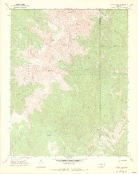
1967 Map of Culebra Peak
USGS Topo · Published 1971About this map
The Sangre De Cristo range dominates this high-altitude terrain, where the rugged peaks of Culebra Peak and Purgatoire Peak form a formidable divide along the boundary between Costilla and Las Animas counties. This 1967 field check reveals a landscape defined by sharp elevation changes and high-mountain hydrology, with water flowing from alpine sources like Leandro Lake into diverse drainage systems including North Vallejos Creek and Vermejo Creek. The eastern portion of the sheet is largely occupied by the Maxwell land grant area, a region characterized by limited human infrastructure save for a network of Jeep Trails that navigate the ridges. Geographic landmarks such as Red Mountain and Vermejo Peak provide fixed points for understanding the early 20th-century ranching and land management patterns of this high-country environment.
Find a feature on this map
23 named features on this map. Tap any name to fly to it.
Don’t see what you’re looking for? This feature index may not catch every label — zoom into the map to look around manually.
Map Details
Editions of this 1967 Culebra Peak Map
2 editions found
Other maps of this area

1954 · Raton
USGS Topo · 1:250,000

1954 · Trinidad
USGS Topo · 1:250,000

1955 · Trinidad
USGS Topo · 1:250,000

1958 · Raton
USGS Topo · 1:250,000

1958 · Trinidad
USGS Topo · 1:250,000

1959 · Trinidad
USGS Topo · 1:250,000

1962 · Ash Mountain
USGS Topo · 1:62,500

1963 · Big Costilla Peak
USGS Topo · 1:24,000

1967 · La Valley
USGS Topo · 1:24,000

1967 · Taylor Ranch
USGS Topo · 1:24,000