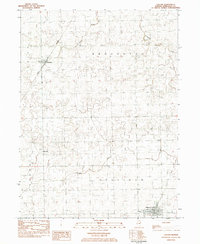
1983 Map of Cullom
USGS Topo · Published 1983About this map
Cullom serves as the primary hub in this eastern Livingston County landscape, situated at the junction of the Illinois Central Gulf railroad and several local routes. The area is defined by a heavy reliance on its rail corridors and small rural townships, including Union, Broughton, Neumann, and Sullivan. The map reveals a transition in transportation infrastructure, documenting both active lines like the Norfolk and Western passing through Emington and an Old RR Grade and Abandoned Railroad further south.
Find a feature on this map
18 named features on this map. Tap any name to fly to it.
Don’t see what you’re looking for? This feature index may not catch every label — zoom into the map to look around manually.
Map Details
Editions of this 1983 Cullom Map
This is the sole edition of this map. No revisions or reprints were ever made.
Other maps of this area

1923 · Herscher
USGS Topo · 1:62,500

1925 · Herscher
USGS Topo · 1:62,500

1944 · Piper City
USGS Topo · 1:48,000

1947 · Piper City
USGS Topo · 1:62,500

1947 · Cullom
USGS Topo · 1:62,500

1948 · Dwight
USGS Topo · 1:62,500

1949 · Cullom
USGS Topo · 1:62,500

1950 · Dwight
USGS Topo · 1:62,500

1958 · Aurora
USGS Topo · 1:250,000

1958 · Peoria
USGS Topo · 1:250,000