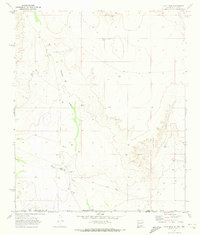
1969 Map of Culp Draw
USGS Topo · Published 1973About this map
Arid drainage patterns and water management define this landscape at the intersection of the Otero Co Hudspeth Co line and the New Mexico Texas border. The topography is dominated by the winding course of Fourmile Draw and its tributary, North Fourmile Draw, which cut through the high desert terrain. Water sources, essential for survival and livestock in this environment, are clearly marked through features like China Pond, Lost Pond, and Joe Tank. Evidence of human industry and infrastructure appears in the form of a Gravel Pit and several named water points such as New Well and Culp Tank. The map specifically highlights the boundary between Otero and Hudspeth counties as it crosses from New Mexico into Texas, providing a precise look at the land use and ranching infrastructure of the late 1960s.
Find a feature on this map
12 named features on this map. Tap any name to fly to it.
Don’t see what you’re looking for? This feature index may not catch every label — zoom into the map to look around manually.
Map Details
Editions of this 1969 Culp Draw Map
This is the sole edition of this map. No revisions or reprints were ever made.
Other maps of this area

1951 · Dell City
USGS Topo · 1:62,500

1954 · Carlsbad
USGS Topo · 1:250,000

1954 · Van Horn
USGS Topo · 1:250,000

1955 · Cerro Diablo
USGS Topo · 1:62,500

1958 · Van Horn
USGS Topo · 1:250,000

1958 · Carlsbad
USGS Topo · 1:250,000

1969 · Lewis Canyon
USGS Topo · 1:24,000
1969 · Sheep Draw
USGS Topo · 1:24,000
1969 · Cienega School
USGS Topo · 1:24,000
1970 · Shiloh Hills SE
USGS Topo · 1:24,000