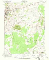
1968 Map of Culpeper
USGS Topo · Published 1970About this map
The town of Culpeper serves as the focal point of this late 1960s survey, showing the community's established infrastructure alongside the Southern railroad lines. The residential and civic landscape is well-defined by the National Cem and Masonic Cem, as well as local education hubs like the County High Sch and Richardson Sch. Beyond the town center, the terrain is characterized by the prominent elevation of Mount Pony and the rolling drainage basins of Mountain Run and Potato Run.
Find a feature on this map
41 named features on this map. Tap any name to fly to it.
Don’t see what you’re looking for? This feature index may not catch every label — zoom into the map to look around manually.
Map Details
Editions of this 1968 Culpeper Map
This is the sole edition of this map. No revisions or reprints were ever made.
Other maps of this area

1887 · Spottsylvania
USGS Topo · 1:125,000

1892 · Spottsylvania
USGS Topo · 1:125,000

1892 · Gordonsville
USGS Topo · 1:125,000

1893 · Luray
USGS Topo · 1:125,000

1894 · Warrenton
USGS Topo · 1:125,000

1894 · Warrenton
USGS Topo · 1:62,500

1905 · Luray
USGS Topo · 1:125,000

1927 · Remington
USGS Topo · 1:48,000

1930 · Warrenton
USGS Topo · 1:62,500

1943 · Germanna Bridge
USGS Topo · 1:24,000