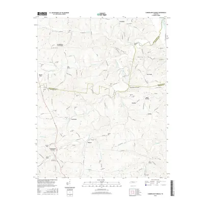
2016 Map of Cumberland Furnace
USGS Topo · Published 2016About this map
Cumberland Furnace serves as the focal point of this region where the borders of Montgomery, Dickson, and Cheatham Counties meet. The landscape is defined by the legacy of early industry and family settlement, evident in the numerous burial grounds such as Cumberland Furnace Cem and Hagewood Cem. Small communities like Stayton, Glenwylde, and McAllisters Crossroads are connected by a network of rural roads that follow the winding paths of Bartons Creek and its many tributaries, including Little Bartons Cr and Fatty Bread Br. The terrain is marked by distinct landmarks like Pinnacle Point and Gallion Hill, while names such as Coaling suggest the historic resource extraction that once supported the local iron works. From the northern reaches of Southside to the hollows of Washer Hollow and Owl Hollow, this map illustrates the enduring rural character of these Tennessee highlands.
Find a feature on this map
118 named features on this map. Tap any name to fly to it.
Don’t see what you’re looking for? This feature index may not catch every label — zoom into the map to look around manually.
Map Details
Editions of this 2016 Cumberland Furnace Map
This is the sole edition of this map. No revisions or reprints were ever made.
Other maps of this area

1930 · White Bluff
USGS Topo · 1:62,500

1933 · White Bluff
USGS Topo · 1:62,500

1956 · Nashville
USGS Topo · 1:250,000

1957 · Cheatham Dam
USGS Topo · 1:24,000

1957 · Henrietta
USGS Topo · 1:24,000

1958 · Charlotte
USGS Topo · 1:24,000

1958 · Cumberland Furnace
USGS Topo · 1:24,000
1958 · Vanleer
USGS Topo · 1:24,000
1958 · Palmyra
USGS Topo · 1:24,000
1958 · Slayden
USGS Topo · 1:24,000