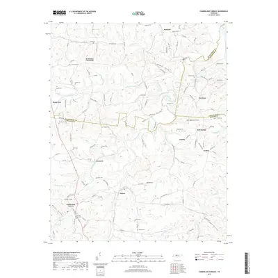
2019 Map of Cumberland Furnace
USGS Topo · Published 2019About this map
Cumberland Furnace and its eponymous cemetery anchor the southern landscape of this region, reflecting the area's deep roots in the early Tennessee iron industry. The terrain is defined by the winding course of Bartons Creek and its many tributaries, such as Little Bartons Cr and Furnace Cr, which carved out deep hollows including Sugar Hollow and Washer Hollow. Small settlements like Stayton, Glenwylde, and McAllisters Crossroads are connected by a network of rural roads that trace the ridgelines and creek bottoms. This map is particularly valuable for genealogical research, documenting numerous family-named burial sites like the Batson Cem, Hagewood Cem, and Nicks Cem. The presence of Coaling and the furnace sites indicates a landscape once centered on resource extraction and charcoal production for iron manufacturing.
Find a feature on this map
118 named features on this map. Tap any name to fly to it.
Don’t see what you’re looking for? This feature index may not catch every label — zoom into the map to look around manually.
Map Details
Editions of this 2019 Cumberland Furnace Map
This is the sole edition of this map. No revisions or reprints were ever made.
Other maps of this area

1930 · White Bluff
USGS Topo · 1:62,500

1933 · White Bluff
USGS Topo · 1:62,500

1956 · Nashville
USGS Topo · 1:250,000

1957 · Cheatham Dam
USGS Topo · 1:24,000

1957 · Henrietta
USGS Topo · 1:24,000

1958 · Charlotte
USGS Topo · 1:24,000

1958 · Cumberland Furnace
USGS Topo · 1:24,000
1958 · Vanleer
USGS Topo · 1:24,000
1958 · Palmyra
USGS Topo · 1:24,000
1958 · Slayden
USGS Topo · 1:24,000