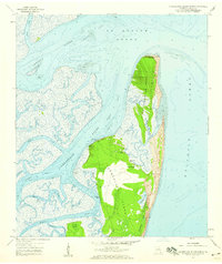
1958 Map of Cumberland Island North
USGS Topo · Published 1959About this map
Little Cumberland Island and the northern reaches of Cumberland Island dominate this coastal survey, revealing a landscape defined by shifting sands and intricate tidal waterways. The northern tip of the island chain is marked by the Little Cumberland Island Lighthouse (Abandoned), which stands near the mouth of St Andrew Sound. Further south, the island's interior features several freshwater bodies, including Whitney Lake and Sweetwater Lake, sheltered by high dunes and maritime forest.
Find a feature on this map
32 named features on this map. Tap any name to fly to it.
Don’t see what you’re looking for? This feature index may not catch every label — zoom into the map to look around manually.
Map Details
Editions of this 1958 Cumberland Island North Map
This is the sole edition of this map. No revisions or reprints were ever made.
Other maps of this area

1918 · Cumberland Island
USGS Topo · 1:62,500

1918 · Bladen
USGS Topo · 1:62,500

1918 · Kingsland
USGS Topo · 1:62,500

1930 · Cumberland Island
USGS Topo · 1:62,500

1939 · Bladen
USGS Topo · 1:62,500

1945 · Brunswick
USGS Topo · 1:62,500

1945 · Cumberland Island
USGS Topo · 1:62,500

1946 · Brunswick
USGS Topo · 1:250,000

1948 · Jacksonville
USGS Topo · 1:250,000

1948 · Brunswick
USGS Topo · 1:250,000