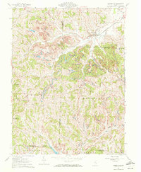
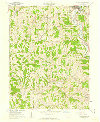
1961 Map of Cumberland
USGS Topo · Published 1972About this map
Cumberland sits at the convergence of several waterways and the Baltimore and Ohio railroad line, serving as a central hub for the surrounding rural townships in the early 1960s. The landscape is deeply dissected by a network of drainage systems including Collins Fork, Buffalo Fork, and Meigs Fork, which separate the prominent elevations of Rich Hill and Spencer. The map reveals a high density of rural infrastructure essential to genealogy and local history, specifically naming Township Sch locations and numerous country churches like Ark Springs Ch and Oak Grove Ch. The settlement pattern follows the ridgelines and creek valleys, connecting smaller communities such as Zeno and Young Hickory through a web of unpaved and improved roads. Notable landmarks like Coal Hill and the Brookfield Cem provide clear points of reference for tracing family homesteads in this multi-county border region.
Find a feature on this map
39 named features on this map. Tap any name to fly to it.
Don’t see what you’re looking for? This feature index may not catch every label — zoom into the map to look around manually.
Map Details
Editions of this 1961 Cumberland Map
4 editions found
Other maps of this area

1909 · Caldwell
USGS Topo · 1:62,500

1910 · Philo
USGS Topo · 1:62,500

1910 · Mc Connelsville
USGS Topo · 1:62,500

1911 · Cumberland
USGS Topo · 1:62,500

1912 · Caldwell
USGS Topo · 1:62,500

1949 · Clarksburg
USGS Topo · 1:250,000

1956 · Clarksburg
USGS Topo · 1:250,000

1961 · Clarksburg
USGS Topo · 1:250,000

1961 · Mc Connelsville
USGS Topo · 1:24,000
1961 · Caldwell South
USGS Topo · 1:24,000