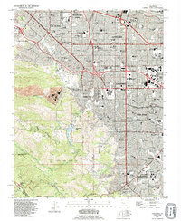
1991 Map of Cupertino
USGS Topo · Published 1995About this map
The Santa Cruz Mountains form a dramatic backdrop to the rapidly expanding suburbs of the South Bay in the early 1990s. This survey illustrates the dense concentration of educational and religious institutions that shaped the region, from the sprawling campus of De Anza College to the St Joseph Seminary and Maryknoll Seminary nestled near the foothills. The landscape is a study in transitions, where the engineered Percolation Basin and the industrial Cement Plant meet the recreational expanses of Blackberry Farm Golf Course and Rancho San Antonio County Park. As the suburban grid of Cupertino and Los Altos pushes against the rugged Monte Bello Ridge, the map records the complex water network of Stevens Creek and Permanente Creek that continues to define the valley's geography and development patterns.
Find a feature on this map
123 named features on this map. Tap any name to fly to it.
Don’t see what you’re looking for? This feature index may not catch every label — zoom into the map to look around manually.
Map Details
Editions of this 1991 Cupertino Map
2 editions found
Other maps of this area

1889 · San Jose
USGS Topo · 1:62,500

1897 · San Jose
USGS Topo · 1:62,500

1897 · Palo Alto
USGS Topo · 1:62,500

1899 · San Jose
USGS Topo · 1:62,500

1899 · Palo Alto
USGS Topo · 1:62,500

1902 · Santa Cruz
USGS Topo · 1:125,000

1916 · New Almaden
USGS Topo · 1:48,000

1919 · New Almaden
USGS Topo · 1:62,500

1940 · Los Gatos
USGS Topo · 1:62,500

1941 · Palo Alto
USGS Topo · 1:62,500