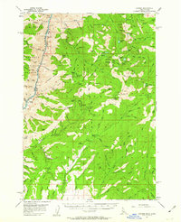
1957 Map of Cuprum
USGS Topo · Published 1963About this map
Cuprum serves as the central hub of this high-elevation landscape along the Snake River, where the deep canyons of the Wallowa National Forest meet the timbered slopes of the Payette National Forest. This 1950s survey captures the region's transition from an active mining district into a managed forest wilderness. The map meticulously records evidence of the area's industrial past, noting the South Peacock Mine, Alaska Mine, and the Bluejacket Mine near several former town sites. While Cuprum remains the primary named community, the presence of Helena (Site) and Landore (Site) highlights the ephemeral nature of mountain settlements in the Seven Devils area. High-altitude infrastructure is represented by the Bear Guard Sta and Jackley Mtn Lookout, which overlook a network of pack trails and early roads connecting family-named landmarks like Lynes Ranch and Barrinaga Corrals.
Find a feature on this map
173 named features on this map. Tap any name to fly to it.
Don’t see what you’re looking for? This feature index may not catch every label — zoom into the map to look around manually.
Map Details
Editions of this 1957 Cuprum Map
3 editions found

Other maps of this area

1911 · Meadows
USGS Topo · 1:125,000

1920 · Seven Devils Mining District
USGS Topo · 1:48,000

1922 · He Devil
USGS Topo · 1:48,000

1938 · Riggins
USGS Topo · 1:96,000

1945 · Riggins
USGS Topo · 1:125,000

1954 · New Meadows
USGS Topo · 1:62,500

1954 · Harl Butte
USGS Topo · 1:62,500

1955 · Baker
USGS Topo · 1:250,000

1955 · Grangeville
USGS Topo · 1:250,000

1957 · He Devil
USGS Topo · 1:62,500