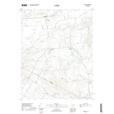
2019 Map of Curdsville
USGS Topo · Published 2019About this map
Curdsville sits at the northern edge of this Daviess County landscape, where the Green River forms the border with Henderson County. The area is defined by a dense network of watercourses, including the extensive drainage of Knoblick Creek and its multiple branches, which shape the agricultural layout of the region. Local heritage is preserved in several small burial grounds such as McCain Cem near the river and Old Macedonia Cem further south, providing fixed points for genealogical research in a landscape of shifting family farms.
Find a feature on this map
77 named features on this map. Tap any name to fly to it.
Don’t see what you’re looking for? This feature index may not catch every label — zoom into the map to look around manually.
Map Details
Editions of this 2019 Curdsville Map
This is the sole edition of this map. No revisions or reprints were ever made.
Other maps of this area

1901 · Owensboro
USGS Topo · 1:62,500

1905 · Newburg
USGS Topo · 1:62,500

1906 · Sutherland
USGS Topo · 1:62,500

1908 · Calhoun
USGS Topo · 1:62,500

1951 · Spottsville
USGS Topo · 1:24,000

1952 · Owensboro West
USGS Topo · 1:24,000

1952 · Reed
USGS Topo · 1:24,000

1952 · Calhoun
USGS Topo · 1:24,000

1952 · Beech Grove
USGS Topo · 1:24,000
1953 · Glenville
USGS Topo · 1:24,000