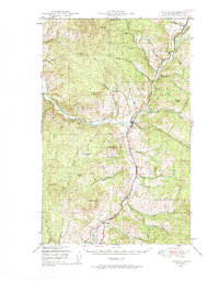
1948 Map of Curlew
USGS Topo · Published 1948About this map
The Kettle River carves a deep valley through the northern reaches of Ferry County, serving as the primary corridor for both the Great Northern railroad and the early settlements of this mountain landscape. In the late 1940s, the village of Curlew sat at a vital junction where the river turns south, while further north, Danville stood just below the United States Canada border. The map illustrates a high-relief terrain dominated by the Colville National Forest, where summits like Vulcan Mtn and Mt Elizabeth overlook narrow creek valleys. To the south, the terrain softens toward Curlew Lake, with the small railroad hamlets of Malo and Karamin marking the line's path through the Curlew Creek valley. Local landmarks such as Lundimo Meadows and a high-elevation Lookout provide specific points of interest for those tracing the history of forestry and homesteading in the Pacific Northwest.
Find a feature on this map
41 named features on this map. Tap any name to fly to it.
Don’t see what you’re looking for? This feature index may not catch every label — zoom into the map to look around manually.
Map Details
Editions of this 1948 Curlew Map
3 editions found
Other maps of this area

1904 · Republic
USGS Topo · 1:125,000

1936 · Marcus
USGS Topo · 1:96,000

1942 · Marcus
USGS Topo · 1:125,000

1948 · Curlew
USGS Topo · 1:62,500

1948 · Republic
USGS Topo · 1:62,500

1948 · Sherman Peak
USGS Topo · 1:62,500

1948 · Togo Mountain
USGS Topo · 1:62,500

1951 · Wauconda
USGS Topo · 1:62,500

1951 · Togo Mountain
USGS Topo · 1:62,500

1951 · Sherman Peak
USGS Topo · 1:62,500