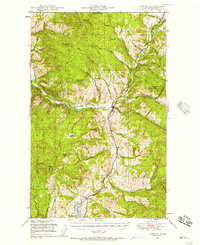
1948 Map of Curlew
USGS Topo · Published 1957About this map
Kettle River defines the corridor of this north-central Washington landscape, where the Great Northern railway navigates the valleys of the Colville National Forest. The map documents a sparsely populated but active region just south of the border with Canada, centered on the small settlements of Danville, Curlew, and Malo. To the south, Curlew Lake serves as a prominent water feature, while the surrounding high ground is marked by strategic sites like the Vulcan Lookout and Franson Pk Lookout. This postwar survey captures the transition from high alpine peaks such as Granite Mtn and Mt Elizabeth to the alluvial flats of Curlew Creek. Small-scale local history is preserved in labels for Lundimo Meadows and a community Cem near the river, reflecting the area's late 1940s development pattern of isolated mountain outposts and riverside rail towns.
Find a feature on this map
61 named features on this map. Tap any name to fly to it.
Don’t see what you’re looking for? This feature index may not catch every label — zoom into the map to look around manually.
Map Details
Editions of this 1948 Curlew Map
3 editions found
Other maps of this area

1904 · Republic
USGS Topo · 1:125,000

1936 · Marcus
USGS Topo · 1:96,000

1942 · Marcus
USGS Topo · 1:125,000

1948 · Curlew
USGS Topo · 1:62,500

1948 · Republic
USGS Topo · 1:62,500

1948 · Sherman Peak
USGS Topo · 1:62,500

1948 · Togo Mountain
USGS Topo · 1:62,500

1951 · Wauconda
USGS Topo · 1:62,500

1951 · Togo Mountain
USGS Topo · 1:62,500

1951 · Sherman Peak
USGS Topo · 1:62,500