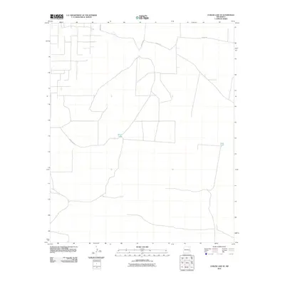
2010 Map of Curlew Lake SE
USGS Topo · Published 2010About this map
High plains ranching infrastructure defines this arid section of Chaves County at the turn of the 21st century. The landscape is marked primarily by water management features essential for livestock in the New Mexico desert, specifically Wilcox Tanks and Sand Tanks. These points of permanence are connected by a sparse network of unpaved access ways, including Hanover Rd and Nogeezi Rd, which cut across the open terrain. The presence of County Rd 50 in the western portion of the sheet suggests a transition toward more established regional thoroughfares, though the overall character remains one of wide-open grazing land and localized water storage sites.
Find a feature on this map
5 named features on this map. Tap any name to fly to it.
Don’t see what you’re looking for? This feature index may not catch every label — zoom into the map to look around manually.
Map Details
Editions of this 2010 Curlew Lake SE Map
This is the sole edition of this map. No revisions or reprints were ever made.
Other maps of this area

1954 · Brownfield
USGS Topo · 1:250,000

1958 · Brownfield
USGS Topo · 1:250,000

1962 · Brownfield
USGS Topo · 1:250,000

1973 · Caprock
USGS Topo · 1:24,000
1973 · Oasis
USGS Topo · 1:24,000

1973 · Mescalero Point NE
USGS Topo · 1:24,000

1978 · Curlew Lake
USGS Topo · 1:24,000
1978 · Presler Lake
USGS Topo · 1:24,000

1978 · Button Mesa North
USGS Topo · 1:24,000
1979 · Curlew Lake SE
USGS Topo · 1:24,000