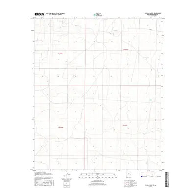
2017 Map of Curlew Lake SE
USGS Topo · Published 2017About this map
Wilcox Tanks and Sand Tanks mark this arid stretch of eastern New Mexico, where water sources have long dictated the movement of people and livestock across the high plains. The landscape is defined by its isolation and the systematic grid of the Public Land Survey System, specifically within township ranges such as t8s r30e and t8s r31e. Modern access is provided by a sparse network of unpaved paths including Nogeezi Rd, Co Rd 39, and Co Rd 40, which traverse the open range between subtle elevation changes. This area of Chaves County remains largely undeveloped, serving as a clear record of the intersection between historic land management practices and the practical requirements of ranching in a dry environment.
Find a feature on this map
9 named features on this map. Tap any name to fly to it.
Don’t see what you’re looking for? This feature index may not catch every label — zoom into the map to look around manually.
Map Details
Editions of this 2017 Curlew Lake SE Map
This is the sole edition of this map. No revisions or reprints were ever made.
Other maps of this area

1954 · Brownfield
USGS Topo · 1:250,000

1958 · Brownfield
USGS Topo · 1:250,000

1962 · Brownfield
USGS Topo · 1:250,000

1973 · Caprock
USGS Topo · 1:24,000
1973 · Oasis
USGS Topo · 1:24,000

1973 · Mescalero Point NE
USGS Topo · 1:24,000

1978 · Curlew Lake
USGS Topo · 1:24,000
1978 · Presler Lake
USGS Topo · 1:24,000

1978 · Button Mesa North
USGS Topo · 1:24,000
1979 · Curlew Lake SE
USGS Topo · 1:24,000