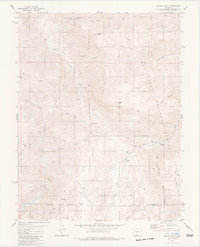
1980 Map of Curley Peak
USGS Topo · Published 1981About this map
San Isabel National Forest dominates this landscape in the Fremont and Custer County borderlands during the mid-1970s. The terrain is defined by a dense network of gulches and peaks, including the prominent Curley Peak and Tanner Peak, which rise above the winding course of Grape Creek. While much of the land remains undeveloped forest, the presence of the small settlement at Yorkville and the Oak Creek Campground indicates established recreational and local residential use.
Find a feature on this map
38 named features on this map. Tap any name to fly to it.
Don’t see what you’re looking for? This feature index may not catch every label — zoom into the map to look around manually.
Map Details
Editions of this 1980 Curley Peak Map
3 editions found
Other maps of this area

1889 · Canon City
USGS Topo · 1:125,000

1892 · Canon City
USGS Topo · 1:125,000

1954 · Mount Tyndall
USGS Topo · 1:24,000

1954 · Pueblo
USGS Topo · 1:250,000

1955 · Westcliffe
USGS Topo · 1:24,000

1957 · Pueblo
USGS Topo · 1:250,000

1958 · Pueblo
USGS Topo · 1:250,000
1959 · Canon City
USGS Topo · 1:24,000

1959 · Rockvale
USGS Topo · 1:24,000

1959 · Royal Gorge
USGS Topo · 1:62,500