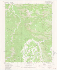
1980 Map of Curley Peak
USGS Topo · Published 1981About this map
The high peaks and drainages of the San Isabel National Forest dominate this 1980 survey, where the winding course of Grape Creek carves through the mountain terrain. Settlement is sparse, centered primarily around the small cluster at Yorkville, while the landscape is defined by its network of pack trails and primitive routes. These paths, such as the Tanner Trail (Pack) and the Stultz Trail (Pack), suggest a history of resource extraction and high-country access rather than dense habitation.
Find a feature on this map
42 named features on this map. Tap any name to fly to it.
Don’t see what you’re looking for? This feature index may not catch every label — zoom into the map to look around manually.
Map Details
Editions of this 1980 Curley Peak Map
3 editions found
Other maps of this area

1889 · Canon City
USGS Topo · 1:125,000

1892 · Canon City
USGS Topo · 1:125,000

1954 · Mount Tyndall
USGS Topo · 1:24,000

1954 · Pueblo
USGS Topo · 1:250,000

1955 · Westcliffe
USGS Topo · 1:24,000

1957 · Pueblo
USGS Topo · 1:250,000

1958 · Pueblo
USGS Topo · 1:250,000
1959 · Canon City
USGS Topo · 1:24,000

1959 · Rockvale
USGS Topo · 1:24,000

1959 · Royal Gorge
USGS Topo · 1:62,500