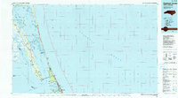
1985 Map of Currituck Sound
USGS Topo · Published 1990About this map
Wright Brothers National Memorial stands near the coast in Kill Devil Hills, marking a landscape defined by the shallow waters and barrier islands of the mid-1980s. This survey details the complex geography of the Currituck Sound, where numerous bays like Bellows Bay and Whale Head Bay are separated by islands including Swan Island and Monkey Island. The Intracoastal Waterway cuts through Coinjock Bay, serving as a critical transit corridor between the North Landing River and the Albemarle Sound.
Find a feature on this map
261 named features on this map. Tap any name to fly to it.
Don’t see what you’re looking for? This feature index may not catch every label — zoom into the map to look around manually.
Map Details
Editions of this 1985 Currituck Sound Map
2 editions found
Other maps of this area

1893 · Virginia Beach
USGS Topo · 1:125,000

1916 · Back Bay
USGS Topo · 1:62,500

1939 · Moyock
USGS Topo · 1:62,500

1940 · Barco
USGS Topo · 1:62,500

1940 · Kitty Hawk
USGS Topo · 1:62,500

1940 · Powells Point
USGS Topo · 1:62,500

1940 · Wade Point
USGS Topo · 1:62,500

1943 · Wade Point
USGS Topo · 1:62,500

1943 · Columbia
USGS Topo · 1:125,000

1943 · Back Bay
USGS Topo · 1:62,500