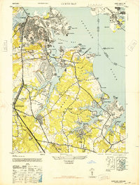
1946 Map of Curtis Bay
USGS Topo · Published 1946About this map
Industrial developments and maritime defenses define this mid-century shoreline along the Patapsco River. The map captures a high concentration of military and logistical infrastructure, including the offshore Fort Carroll, the land-based Fort Armistead Park, and the expansive U S Army Ordnance Depot west of Curtis Bay. The landscape transition from the dense urban grids of Brooklyn and Fairfield in the north to the burgeoning suburban beach communities of Marley Neck is clearly visible. This era shows a coastal economy in flux, where traditional maritime sites like the U S Quarantine Station at Leading Point exist alongside a growing Municipal Airport and the heavy rail corridors of the Baltimore and Ohio and Pennsylvania railroads. Inland, the importance of family and community history is anchored by several large burial grounds, such as Cedar Hill Cemetery and Glen Haven Park Cemetery.
Find a feature on this map
98 named features on this map. Tap any name to fly to it.
Don’t see what you’re looking for? This feature index may not catch every label — zoom into the map to look around manually.
Map Details
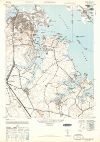
Editions of this 1946 Curtis Bay Map
2 editions found
Other maps of this area

1893 · North Point
USGS Topo · 1:62,500

1893 · Gunpowder
USGS Topo · 1:62,500

1894 · Baltimore
USGS Topo · 1:62,500

1894 · Relay
USGS Topo · 1:62,500

1898 · Tolchester
USGS Topo · 1:125,000

1899 · Baltimore
USGS Topo · 1:62,500

1901 · Gunpowder
USGS Topo · 1:62,500

1903 · Tolchester
USGS Topo · 1:125,000

1904 · Baltimore
USGS Topo · 1:62,500

1904 · North Point
USGS Topo · 1:62,500