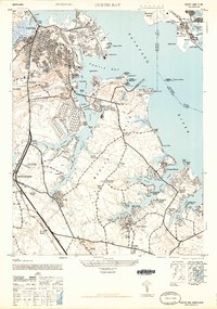
1946 Map of Curtis Bay
USGS Topo · Published 1946About this map
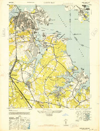
The industrial and maritime activity along the Patapsco River and Curtis Bay is captured here just after the war. The map reveals a landscape defined by heavy transport and defense, where the Baltimore and Ohio and Pennsylvania railroads serve a complex network of docks and depots. Significant military and municipal installations occupy the shoreline, including the U S Army Ordnance Depot and the US Naval Magazine near Hawkins Point. Moving south, the map transitions into the residential and recreational shoreline communities of the Marley Neck peninsula. Areas like Orchard Beach, Riviera Beach, and Lombardee Beach sit alongside established landmarks such as Marley Neck Church. The infrastructure of the era is prominent, featuring the Governor Ritchie Highway and the Municipal Airport situated north of the river near Sollers Point.
Find a feature on this map
96 named features on this map. Tap any name to fly to it.
Don’t see what you’re looking for? This feature index may not catch every label — zoom into the map to look around manually.
Map Details
Editions of this 1946 Curtis Bay Map
2 editions found
Other maps of this area

1893 · North Point
USGS Topo · 1:62,500

1893 · Gunpowder
USGS Topo · 1:62,500

1894 · Baltimore
USGS Topo · 1:62,500

1894 · Relay
USGS Topo · 1:62,500

1898 · Tolchester
USGS Topo · 1:125,000

1899 · Baltimore
USGS Topo · 1:62,500

1901 · Gunpowder
USGS Topo · 1:62,500

1903 · Tolchester
USGS Topo · 1:125,000

1904 · Baltimore
USGS Topo · 1:62,500

1904 · North Point
USGS Topo · 1:62,500