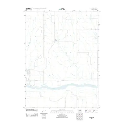
2011 Map of Cushing
USGS Topo · Published 2011About this map
Cushing sits as the primary settlement on this Nebraska landscape, situated just north of the wide valley where the Loup River flows eastward. The town's grid is small and orderly, bounded by Cushing Rd and Center Ave. This 2011 survey reveals a landscape defined by water management and rural interment, centered around the Deppen Reservoir and its associated Deppen Dam. To the east, the rural character is underscored by the presence of Rock Creek Cemetery, located near the winding course of Rock Creek. The surrounding territory is divided into a systematic agricultural grid, with long stretches like Pleasant Valley Rd and Merrick Rd connecting isolated farmsteads across the plains. Tributaries such as Spring Creek and Cottonwood Creek further mark the drainage patterns that influence local land use.
Find a feature on this map
29 named features on this map. Tap any name to fly to it.
Don’t see what you’re looking for? This feature index may not catch every label — zoom into the map to look around manually.
Map Details
Editions of this 2011 Cushing Map
This is the sole edition of this map. No revisions or reprints were ever made.
Other maps of this area

1899 · St. Paul
USGS Topo · 1:125,000

1954 · Wolbach
USGS Topo · 1:24,000

1954 · Wolbach NE
USGS Topo · 1:24,000

1954 · Belgrade NW
USGS Topo · 1:24,000

1955 · Belgrade SW
USGS Topo · 1:24,000

1955 · Broken Bow
USGS Topo · 1:250,000

1955 · Wolbach SW
USGS Topo · 1:24,000

1955 · Cushing
USGS Topo · 1:24,000

1956 · Broken Bow
USGS Topo · 1:250,000
1960 · St. Paul
USGS Topo · 1:24,000