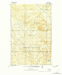
1910 Map of Cuskers
USGS Topo · Published 1975About this map
The Fort Peck Indian Reservation dominates this landscape in northeastern Montana, surveyed by the General Land Office just after the turn of the century. The terrain is characterized by the winding course of the Poplar River in the northeast and a network of drainages including Boxelder Creek and East Branch Chelsea Creek to the south. Human presence is sparse on this 1910 sheet, with Cuskers House serving as a primary landmark in the river valley. The topography reveals a complex system of coulees and ridges typical of the Missouri Plateau, offering a clear record of the area's geography before significant 20th-century development. Genealogists and historians can trace the early allotment-era layout of the reservation and the specific locations of early habitations in this corner of Sheridan County.
Find a feature on this map
12 named features on this map. Tap any name to fly to it.
Don’t see what you’re looking for? This feature index may not catch every label — zoom into the map to look around manually.
Map Details
Editions of this 1910 Cuskers Map
2 editions found
Other maps of this area

1910 · Cuskers
USGS Topo · 1:62,500

1912 · Chelsea
USGS Topo · 1:62,500

1912 · Hay Creek
USGS Topo · 1:62,500

1912 · Poplar
USGS Topo · 1:62,500

1915 · Tule Valley
USGS Topo · 1:62,500

1915 · Cuskers
USGS Topo · 1:62,500

1916 · Wolf Point
USGS Topo · 1:62,500

1954 · Wolf Point
USGS Topo · 1:250,000

1958 · Wolf Point
USGS Topo · 1:250,000

1972 · Chelsea
USGS Topo · 1:24,000